A Hiker's Story
First Trip Into Willmore: A Hiker's Story
We meet Rocky and Ann, our outfitters and guides, at the trailhead.
Before this trip, I was a dedicated backpacker and skeptical about joining a horse-assisted trip – who wants to be around a bunch of horses? But a friend said, "Face it, we're getting older. On this trip the horses will carry the heavy camp gear, tents, sleeping bags, kitchen gear, tarps, etc. while we hike with light day packs."
It sounded too good to pass up.
As I watched the horses being packed, I had mixed feelings – the backpacker's disdain for horses and riders – nothing had ever carried my pack before. But, a new adventure was unfolding. The entire 200 mile trip would be in a relatively empty wilderness that contained no bridges, no roads or buildings [besides historical trapper's cabins and the occasional forest service cabins] and few, if any, people.
When I hoisted my day pack it was a mere 20 pounds of rain gear, camera, and lunch instead of the usual 60. Maybe travelling this way wouldn't be so bad. The other 40 pounds of my gear would be carried by the horses. And, the horses would carry an additional 50 pounds per person including amenities like a large storm tent in which a person could escape the elements in the event of heavy rain or a summer blizzard, which is always a possibility in the Northern Rockies. What backpacker hasn't been stuck in a small backpacking tent for days on end waiting for the rains to stop?
The first few kilometres into Willmore were disillusioning. I was used to hiking in big mountains on alpine and sub-alpine trails. But, we were following the heavily forested, relatively flat Wildhay River valley on an old dirt road that had been built 80 years earlier to fight a forest fire and put in seismic lnes and then abandoned. I asked myself as I trudged along, "Why I had I elected to spend two weeks in a place like this?"
At the 4 km point we came to the first stream crossing. There are no foot bridges in the park, which is an attraction to wilderness lovers, but the river was knee deep and cold. It can be high enough in spring runoff or after heavy rains to make it impossible to cross safely on foot and, on occasion, even to safely cross on horseback. But, today it was merely a wade through chill waters that made you want to scream by the time you reached the other bank. Next time bring wet suit sox, I told myself. The bridgeless crossing sparked an awareness that I was embarking on 14 days of travel through 400 hundred square kilometers of wilderness.
More good news came over the next 10 kilometers: the Wildhay valley broadened out and the Berland Mountain Range to the East and the Persimmon Mountain Range to the West began poke up above the softly contoured fir and aspen benches. This wasn't the big mountain country of Jasper and Banff, but the willow bottoms and the gentle ridges and peaks on either side of Eagle's Nest Pass made for a pleasing, human scale experience, one that I've now come to prefer to the crowded Rocky Mountain trails in Jasper and Banff National Parks.
We pitched our tents that first night in a camp 20 kilometers in at the Eagle's Nest Pass region. No other camps or people or horses but our own were in sight. At the campfire, Rocky and Ann told us that our next camp on Persimmon Creek was l6 km up the Wildhay valley but that we could avoid the horse trail by climbing and then walking the ridge that runs between the Wildhay and Pope Thoreau Creek Valleys. Years later, I still remember eyeing the ridge from camp and then openng my topo map to estimate the difficulty. It looked doable and inviting and it offered a 13 km walk in the sky. We were a group of eight hikers, some of whom had backpacking experience and others who had never been into the back country. Two were novices who had done several weeks of serious in-city walking to get in shape.
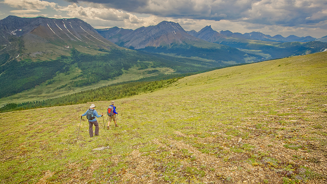
Setting a pace that was enjoyable for everyone, we made our way to the top of the ridge, moving through old growth spruce and pine forests, and then into open slopes covered in alpine wildflowers. An hour later, on top, I lost all concern about having come to the wrong place. The scenery offered views of the Persimmon and Hoff Ranges with the lush green willow valleys of the Wildhay and Pope Thoreau Creeks on either side. Some of the best scenery in the Canadian Rockies!
We walked the full day through fields of wildflowers and along rocky buttresses of an serpentine, but safe, ridge-top, spotting caribou and big horn sheep. Everywhere, we enjoyed a 360-degree panorama of mountains, basins, lakes and valleys. En route, we followed trace trails across scree ridges made not by humans or horses, but by a millenia of sheep, goats and caribou travelling these same pathways. While we walked in the sky above the valleys, the horses carried our gear on the horse trails below. From sun up to sunset, we never saw them. Nor did we meet any other hikers.
Toward the end of the day, we picked a route off the ridge and hiked a further 3 km to our second day camp on Persimmon Creek. We pitched our tents, two of us prepared dinner, and we settled in for what became a regular campfire briefing on the next day's possibilities.
We decided to do a layover day, and in the morning we made our way up Persimmon Creek, a headwaters branch of the South Berland. The hiking was the best of my life in mountains anywhere – and this place also was empty or riders or hikers. We wound our way deep into the vastness of the Persimmon Basin, traveled to the top of its surrounding ridge, moved along that ridge to the top of the South Berland Basin, and traveled down and back to camp–a 16 km cross-country circuit. En route, we saw a group of 32 goats and numerous big horn sheep.
Throughout the trip, we continued to alternate moving and layover days. When we didn't move we made day-long excursions into remote, seldom-visited basins.
That first trip wound through places whose names and beauty captured the imagination. We crossed Jack Knife Pass, moved up the West Sulfur River, and then went into the vastness of the Hardscrabble Pass area, more than 80 kilometers from our starting point.
It was 16 days later that we returned along the Rock Creek Valley to the East of the Starlight Range and made our way back through Eagle's Nest Pass and to the staging area. Our feet had toughened up, we had gotten leaner, and even the most advanced couch potato in our group had no trouble with the ridge hikes.
My thoughts about the Willmore at the end of that first trip were overwhelmingly positive. Willmore is a gentle, human scale wilderness. Compared to the deep, heavily treed valleys of Banff and Jasper, Willmore valleys are wide, the mountain ridges are less high, the forests are more open, and the streams more easily crossed than those in the Rocky Mountain parks: Waterton, Jasper and Banff.
It's possible to hike off-trail to the top of most Willmore ridges and to the tops of many peaks in complete safety with one to two hours of moderate effort. The ridges tend to be open, alpine grasslands that can be walked for hours. The numerous deep basins make for day-long excursions into places where one has a sense of no other humans ever having set foot. Daily sightings of sheep and goats and less frequent sightings of moose, woodland caribou, wolves and grizzlies makes the value of preserving extensive areas of wilderness apparent.
It is those thoughts that have brought me back to the Willmore every summer since that first trip. I hope that you are able to enjoy the Willmore, or if not the Willmore, then some other big wilderness, as I have.
Notes on Willmore camps and hiking:
A wonderful aspect of the Willmore is its numerous, extensive basins. Each basin contains its own special features: waterfalls, lakes, small clear streams, wildflowers, and surrounding peaks. And each basin is empty of human infrastructure and people.
Most Willmore campsites are primitive. Some suffer from the impact of horses, overgrazing, tree hackings and litter–although responsible Willmore outfitters have taken control of this problem in the last ten years. Because we spent most of each day on the ridges, the physical condition of the camps was unimportant. However, we cleaned up several of the camps and I've noted years later that the early abuse of the camps has not been repeated.
The camps are located for their proximity to small streams. They offer shelter for hikers and grazing for the horses. Although we preferred cooking over an open fire, the large cook tent provided a place to dry off after a wet day which is inevitable on extended trips into any part of the Northern Rocky Mountains.
The best times for hiking in Willmore are mid-summer, late June, July, and August. In late August when the hunting season begins, the camps fill with hunters. This isn't to say that hiking is dangerous during this period. The hunter are after Big Horn Sheep and Mountain Goats and have to carefully scope the animals in order to determine whether they are legal. Thus, hunting accidents are unlikely and I'm aware of no accidents involving hikers. However, acquiring a camp during this busy period is a problem and there's lots of horse traffic especially on the trail in.
For the most part, Willmore seems empty during the mid-summer season. Weekends are sometimes buy and hikers will pass outfitters and private parties on the trail in to Eagle's Nest. But for the most parts, hikers won't encounter riders or hikers on the hikes they take even in the Eagle's Nest region. And, even if not with an outfitter, they can count in finding a campsite that is unoccupied.
At present, permits aren't required for hiking in Willmore. Wood gathering and cutting of dead standing trees is permitted. Over the years, this has produced a sparseness of dead standing trees in and near the campsites. However, backpackers don't require the extra-dry wood that comes from a dead standing tree. Over time, one suspects that the cutting and use of wood will have to become regulated. The tin wood burning stoves used by most horse outfits require very dry wood and trees are becoming increasingly difficult to find near the camps. This is likely to eventually lead to the kinds of problems one can readily observe in the heavily used areas like the Ram Wilderness where users are ringing trees in order to kill them and create more dead standing timber near the campsites.
Ray Rasmussen is not a professional guide. Each summer he organizes groups of friends and strangers, connects them with an outfitter and enjoys joining them on trips and offering hiking advice. He pays his own way on all trips. He is not paid by outfitters to advertise their services. The outfitters he recommends are only those with whom he has had personal experience. While he has used the services of numerous outfitters over the years, many are no longer in business, so Ray's list of references is short.